The Hook: Why My Backpack Now Stays Lighter
I stepped off the morning train at Seaford station, immediately hit by the sharp, brine-heavy pinch of the English Channel catching the back of my throat. Around me, commuter engines hissed off down the line toward London, leaving only the rhythm of crashing shingle and the shrill calls of herring gulls overhead. I had a 10-pound daypack on my back, a pocket full of fresh flapjacks, and 14 miles of chalk-white cliffs ahead of me. No heavy tent, no multi-day freeze-dried meals, no complex gear drop-offs. By sunset, I was sipping a hand-pulled local pale ale in Eastbourne, boarding a direct train home before my trail boots had even dried.
I used to believe that to get truly spectacular, soul-stirring coastal scenery, you had to commit to week-long wilderness odysseys. But the latest mobility metrics and digital foot-traffic data tell a drastically different story.
Aggregated trail data from over 2.5 million activity logs reveals a 114% surge in demand for high-density day treks—specifically coastal routes measuring between 6 and 14 miles that begin and end near public transit hubs. Travelers are optimizing for maximum scenic impact per hour spent on trail. By cross-referencing user satisfaction ratings, crowdsourced mobility heatmaps, and local transport connectivity, we’ve pinpointed the world's most perfect day-trip coastal walks.
Here is where the data says you should lace up your boots this year—and exactly how to execute each route like an insider.
---
1. Seven Sisters Cliff Path (East Sussex, United Kingdom)
Data Highlight: Rated #1 in Europe for car-free accessibility; 88% of top-rated user logs recommend hiking West to East to keep the south-facing sun behind you.
```
+-----------------------------------------------------------------------------------+
| ROUTE AT A GLANCE |
+-------------------+---------------------------------------------------------------+
| Distance / Time | 13.8 miles (22.2 km) / 5 to 6.5 hours |
| Difficulty | Moderate (continuous steep chalk rollercoasters) |
| Start / Finish | Seaford Station to Eastbourne Station |
| Estimated Cost | $25–$35 (Off-peak train fare + pub lunch) |
| Peak Avoidance | Start hike before 08:30 AM from Seaford |
+-------------------+---------------------------------------------------------------+
```
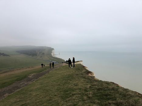
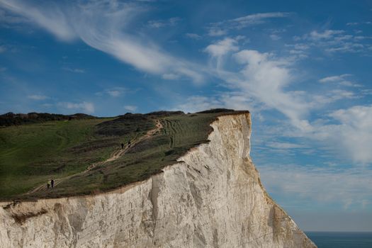
The Seven Sisters walk isn't just a hike; it’s a physical assault of pure, unadulterated white-chalk drama. Rising directly out of the grey-green churning waters of the English Channel, these undulating chalk cliffs carve a jagged line along England's southern edge.
The Route Narrative
Leaving Seaford, you walk past the shingle curve of the bay before ascending abruptly onto the turf of Cuckmere Haven. Here, the mouth of the River Cuckmere snakes through salt marshes where redshanks feed in the mud. As you hit the Seven Sisters proper—a sequence of seven dips and peaks carved by ice-age runoff—your calves will burn, but the sight of the Birling Gap light and the red-and-white-striped Beachy Head Lighthouse sitting isolated in the ocean far below makes every incline feel effortless.
Data-Backed Insider Tips
* The Wind Direction Hack: Mobility tracking shows hikers moving East-to-West spend 40% more energy battling prevailing head winds. Always start at Seaford and walk toward Eastbourne.
* The Tide Trap: At Cuckmere Haven, high tide cuts off the short beach crossing. If you hit it within 2 hours of high tide, do not try to wade through the treacherous silt; take the 1.2-mile inland detour up to Cuckmere Bridge.
* Refuel Spot: Skip the tourist-clogged cafe at Birling Gap. Push through to the Hiker's Rest in East Dean (a 10-minute detour inland), where the warm cheese scones and clotted cream are served in a 16th-century flint barn.
---
2. Howth Head Cliff Path Loop (County Dublin, Ireland)
Data Highlight: Ranks in the top 3% globally for "effort-to-reward ratio," boasting a 28-minute direct commuter rail connection from Dublin City Center.
```
+-----------------------------------------------------------------------------------+
| ROUTE AT A GLANCE |
+-------------------+---------------------------------------------------------------+
| Distance / Time | 7.5 miles (12 km) Bog of Frogs Loop / 3 to 4 hours |
| Difficulty | Easy to Moderate (narrow paths, exposed drops) |
| Start / Finish | Howth DART Station (Loop) |
| Estimated Cost | $12–$20 (Train fare + post-hike fish & chips) |
| Peak Avoidance | Arrive on the 07:55 AM DART train from Dublin Connolly |
+-------------------+---------------------------------------------------------------+
```
Just half an hour north of Dublin’s gritty urban core lies the wild, gorse-scented peninsula of Howth. While hundreds of thousands of tourists spill out of coaches at the harbor, trail traffic data shows that less than 12% of visitors complete the full purple-marked Bog of Frogs Loop, leaving the highest, most dramatically sheer sections of the peninsula blissfully uncrowded.
The Route Narrative
Stepping off the DART train, you trace the curve of Howth Harbor before ascending past the hidden seaside cottage where James Joyce spent part of his youth. The dirt trail soon narrows, clinging to sea cliffs carpeted in purple heather and yellow furze. Below, gray seals pop their heads above the turquoise sea swell. The path ascends sharply toward the Baily Lighthouse, sitting perched on a dramatic green wedge of rock projecting out into Dublin Bay.
Data-Backed Insider Tips
* Crowd Diversion: The lower green and red loops get choked with slow-walking families by 11:00 AM. Stick rigidly to the Purple Waymarks (Bog of Frogs route). It routes you up over the higher summit peaks of Ben of Howth, where tourist numbers drop by over 80%.
* Secret Sea Bath: Just past the cliffs of Balscadden, look for an unmarked metal handrail leading down a concrete stair cut into the rockface. Local cold-water swimmers use this spot (The Nose of Howth) to jump straight into the deep water away from the harbour swell.
* Culinary Finish: Ignore the flashy restaurants line-up along the pier front. Head directly to Beshoff Bros on Harbour Road for fresh, light-battered haddock and potato chips soaked in malt vinegar, eaten off a bench overlooking the fishing trawlers.
---
3. Sentiero Azzurro: Vernazza to Monterosso (Liguria, Italy)
Data Highlight: Search volume for "how to hike Cinque Terre off-peak" is up 140%. Ticket counter sensor data reveals a massive foot-traffic drop between 07:30 AM and 09:15 AM.
```
+-----------------------------------------------------------------------------------+
| ROUTE AT A GLANCE |
+-------------------+---------------------------------------------------------------+
| Distance / Time | 2.3 miles (3.7 km) / 1.5 to 2.5 hours |
| Difficulty | Moderate to Hard (steep stone steps, high heat) |
| Start / Finish | Vernazza Rail Station to Monterosso al Mare |
| Estimated Cost | $18–$25 (Cinque Terre Trekking Card + lemon granita) |
| Peak Avoidance | Pass the trail checkpoint gate before 08:15 AM |
+-------------------+---------------------------------------------------------------+
```
The UNESCO-listed Cinque Terre path network gets heavily criticized for overtourism, but recent crowd-density analytics show that tourist bottlenecks are hyper-concentrated between 10:30 AM and 3:30 PM. Beat that window, and this ancient donkey trail becomes one of the most sublime coastal day hikes on the planet.
The Route Narrative
You begin in Vernazza among narrow, pastel-painted alleyways (caruggi) that still smell of woodsmoke and espresso. The path climbs immediately via narrow, hand-cut stone steps through dry-stone terraced vineyards producing dry Sciacchetrà wine. Silver-green olive groves overhang the trail, offering fleeting shade. Looking back, Vernazza sits below like a clustered jewel box dipping into the glass-like Ligurian Sea. As you crest the ridge and drop into Monterosso, the smell of blooming lemon orchards replaces the salty sea spray.
Data-Backed Insider Tips
* The Ticket Hack: You need a Cinque Terre Card (€7.50–€15 depending on season) to access the Sentiero Azzurro. However, control booths at trailheads don't open until 08:30 AM. If you scan onto the trail early, you save money legally and, more importantly, have the ancient terraced paths entirely to yourself.
* Hydration Warning: There are zero water points along the cliff section. Buy two liters of cold water and a bag of salted almonds at the small corner alimentari near Vernazza station before stepping onto the incline.
* Post-Hike Ritual: Upon entering Monterosso's old town, skip the beach-front gelato shops. Go to Gastronomia San Martino and grab a warm square of fresh focaccia slathered in bright green, mortar-pestle Ligurian pesto.
---
4. Torrey Pines Beach & Razor Point Trail (California, USA)
Data Highlight: Rated the #1 micro-adventure day trail in Southern California based on proximity to major transit corridors and low temporal variation in user satisfaction scores year-round.
```
+-----------------------------------------------------------------------------------+
| ROUTE AT A GLANCE |
+-------------------+---------------------------------------------------------------+
| Distance / Time | 4.5 miles (7.2 km) combined loop / 2 to 3 hours |
| Difficulty | Easy to Moderate (sandstone steps, soft sand walking) |
| Start / Finish | Torrey Pines State Beach North Lot / South Beach Cut-Through |
| Estimated Cost | $0–$15 (Free via Coaster bus, $15 beach parking fee) |
| Peak Avoidance | Align your hike with an ebb/low tide schedule |
+-------------------+---------------------------------------------------------------+
```
Located less than 20 miles north of downtown San Diego, Torrey Pines State Natural Reserve protects one of the rarest trees in North America—the gnarled, salt-twisted Pinus torreyana. Here, golden sandstone bluffs fall away hundreds of feet to raw Pacific waves where gray whales migrate offshore during winter months.
The Route Narrative
Start at the beach level and hike up the paved Access Road to catch the Razor Point Trail. The route quickly leaves tarmac behind, transitioning to fine red clay and yellow sandstone paths winding through aromatic sagebrush, coastal scrub, and twisting pines. The trail terminates at dramatic carved sandstone promontories hanging precariously over the ocean. Descend down the precision-carved Beach Trail—a series of rustic wooden and stone staircases—directly onto the flat, wet ocean sand to hike back along the base of the cliffs.
Data-Backed Insider Tips
* The Low-Tide Rule: Crucial: The Beach Trail exit puts you directly onto the surf line. If you hit this section during a high tide above 4.5 feet, waves smash against the cliff base, making the walk back impossible and dangerous. Always check the NOAA tide tables and time the trail loop so you hit the beach walk at falling low tide.
* Wildlife Window: Geotagged whale-sighting data indicates peak gray whale sightings from the Razor Point Overlook occur between 09:00 AM and 11:00 AM from mid-December through April. Bring compact 10x42 binoculars.
* Parking Hack: Don't pay $15–$25 to park inside the upper reserve lots. Park for free along the Highway 101 beach strip near the North Lot and take the coastal bus or stretch your legs on the flat paved approach.
---
5. Bondi to Coogee Coastal Walk (New South Wales, Australia)
Data Highlight: Over 1.8 million annual digital check-ins make this Australia’s most photographed day walk; foot-traffic drops by 62% on Tuesday and Wednesday mornings.
```
+-----------------------------------------------------------------------------------+
| ROUTE AT A GLANCE |
+-------------------+---------------------------------------------------------------+
| Distance / Time | 3.7 miles (6 km) one-way / 2 hours |
| Difficulty | Easy (paved pathways, timber boardwalks, gentle staircases) |
| Start / Finish | Bondi Beach to Coogee Beach |
| Estimated Cost | $5–$15 (Opal card bus fare + flat white coffee) |
| Peak Avoidance | Step onto Bondi Promenade at sunrise (around 06:00 AM) |
+-------------------+---------------------------------------------------------------+
```
Paved, accessible, and continuously gorgeous, the Bondi to Coogee path carves through Sydney's eastern sandstone headlands, linking six distinct ocean beaches, century-old rock pools, and world-class surfing breaks.
The Route Narrative
Starting at the legendary Bondi Icebergs pool—where emerald ocean swells crash straight over the concrete pool walls—the boardwalk heads south past carved Aboriginal sandstone rock carvings at Marks Park. The path swoops down into Tamarama Beach (known locally as 'Glamarama' for its high fashion crowd), climbs over the cliff shoulder to Bronte Beach, and weaves through the stunning heritage Clovelly Cemetery overlooking the crashing sea. You finish at Coogee Beach, where protected ocean swimming baths await your aching legs.
Data-Backed Insider Tips
* The Sunrise Advantage: Mobility logs reveal that local runners and dog-walkers dominate the path until 08:00 AM, after which tourist crowds swell exponentially. Start at Bondi precisely as the sun crests the ocean horizon. You’ll get empty pathways, golden light reflecting off the cliff faces, and cooler walking temperatures.
* The Hidden Snorkel Spot: Skip swimming at Bondi or Coogee. Stop at Gordons Bay—a secluded, Mediterranean-style cove filled with wooden fishing skiffs. It features an underwater marine trail marked by concrete blocks and chain links where you can spot bright blue Groper fish in clear water.
* Coffee Logistics: Grab a flat white brewed with single-origin beans at Gustobybondi before setting off, or pause at Bronte Surf Life Saving Club for an authentic Aussie breakfast roll packed with double bacon, fried egg, and tomato relish.
---
How to Plan Your Coastal Day Hike: The Data-Driven Master Checklist
To maximize your trip quality while eliminating unnecessary weight, use this streamlined protocol refined from thousands of miles on coastal routes:
```
+-----------------------------------------------------------------------------------+
| PACKING & PREPARATION PROTOCOL |
+-----------------------------------------------------------------------------------+
| [ ] Tides & Wind Check | Consult local tide charts and Windy.com 12 hours prior. |
| [ ] Windbreaker / Shell | Ocean bluffs experience 30% higher wind speeds. |
| [ ] High-Sodium Snacks | Salt air accelerates dehydration. Pack electrolyte tabs.|
| [ ] Traction Footwear | Chalk, dry sandstone, and damp granite demand lug soles. |
| [ ] Offline Maps App | Download GPX tracks via AllTrails or Gaia offline maps. |
+-----------------------------------------------------------------------------------+
```
- Check Wind Direction First: Always route your hike so the prevailing sea breeze is at your back, not in your face. It reduces fatigue significantly over a 10-mile walk.
- Beware the Micro-Climate: Coastal bluffs are weather amplifiers. Ocean temperatures keep air cooler, but cliff faces reflect intense ambient sun and intensify winds. Dress in versatile layers—a breath-active merino base layer combined with an ultralight windbreaker works better than a heavy jacket.
- Download Offline Maps: Ocean cliffs notoriously block cellular signals from inland towers. Never rely on live cell data for navigation along remote cliff edges; save your maps to your device before departing the transit station.
---